


| Getting your Trinity Audio player ready... |


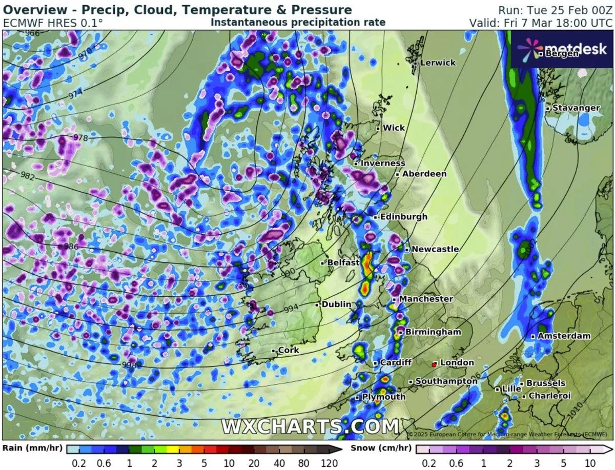
Advanced weather modelling indicates that snow is set to hit the UK within days, stretching across a 600-mile expanse of the country. According to the ECMWF weather model, snow flurries are expected to arrive from the Atlantic on March 7, initially impacting Northern Ireland before drifting eastward and blanketing large parts of England and Scotland by 6 pm.
Cities including Birmingham and Manchester are predicted to face the brunt of this wintry blast. The heaviest snowfalls are anticipated in rural areas of northern England and the Scottish Highlands, where flurries could fall at a staggering rate of around 10cm (four inches) per hour.


Snow is expected to continue falling across western regions throughout March 7 and into the early hours of March 8, with both northern and southern Wales also likely to receive a dusting. The forecast suggests snow will move eastward on March 8, covering much of the Midlands and southern England by midday. In the West Midlands, snowfall rates could reach up to 3cm per hour.

Snow Accumulation and Extent
Maps for March 8 reveal the vast reach of this Arctic blast, with snow settling from the southwest of England to the far north of Scotland. The heaviest accumulations are expected in the Pennines (up to 6cm) and western Scotland (up to 13cm).
Met Office Outlook
Although the Met Office has not yet issued specific snow warnings for this period, it has highlighted the possibility of “chilly nights” and “unsettled conditions.” Its forecast for March 2 to March 11 suggests a likely split in weather patterns across the UK.

Northwestern areas are predicted to experience periods of rain and strong winds due to Atlantic weather systems moving in from the west. These wet and windy spells may extend southeast at times. Conversely, high pressure is expected to dominate southern parts of the UK initially, bringing drier and finer weather, with potential for night frosts and morning fog patches.
As the period progresses, there is an increasing likelihood of more unsettled conditions spreading across the UK. Temperatures are generally expected to remain around average, with some chilly nights interspersed with milder periods.
North East England Weather Forecast (Next 7 Days in Celsius)
- Tuesday, February 25: Partly cloudy with sunny intervals. High: 10°C, Low: 2°C
- Wednesday, February 26: Mostly cloudy with occasional showers. High: 7°C, Low: 2°C
- Thursday, February 27: Sunny spells with a few clouds. High: 9°C, Low: 1°C
- Friday, February 28: Mostly sunny. High: 9°C, Low: 2°C
- Saturday, March 1: Cloudy with light morning rain. High: 9°C, Low: 3°C
- Sunday, March 2: Overcast. High: 11°C, Low: 7°C
- Monday, March 3: Mostly cloudy. High: 11°C, Low: 4°C
Residents are advised to stay informed with the latest updates as conditions can change rapidly.